


Dholavira had been on my wish list for a long time. Since childhood, visiting the Indus Valley sites of Harappa and Mohenjo-daro was a dream. Due to political realities of our times, it is still a dream. However, thanks to recent archaeological discoveries, I was fortunate enough to visit Lothal and Rupnagar a few years ago, explore Rakhigarhi last year, and finally experience Dholavira this year.
Our journey began from Narayan Sarovar, on the western edge of India, driving towards Dholavira through the fascinating Kadhiya Dhroh gorge. By late evening, we reached the famous 31 km road, often called the “road to heaven,” which connects Khadir Bet Island to the mainland. Dholavira is uniquely situated on an island surrounded by the pristine white expanse of the Rann of Kutch.
The next morning, we walked from our resort to the Dholavira heritage site. The broad, empty roads reflected a lean tourist season, making the stroll peaceful and enjoyable. The site opens at sunrise, and we arrived just as the sun appeared. The guards were still preparing to open, the museum was closed and no guides were available early in the morning. Undeterred, we simply entered and immersed ourselves in the photo documentation lining the walkway.
What is Dholavira?
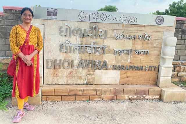
Dholavira is a UNESCO World Heritage Site located on the Tropic of Cancer. It is the sixth largest Indus Valley site on the Indian subcontinent and the second largest in India, after Rakhigarhi. Officially discovered by Jagatpati Joshi in 1967-68 following its local discovery, excavations continued until 2005. The site is named after a nearby village.
Archaeologists reveal that Dholavira was a well-planned city inhabited for at least 1,500 years. Situated between two seasonal rivers, Mansar and Manhar, it boasts a citadel-like structure and elaborate water management systems. Evidence suggests it was a manufacturing and trading hub with far-reaching commercial links, specially with West Asia.
Architecture
Spanning 54 acres, Dholavira’s layout forms a parallelogram trapped between the Mansar River to the north and the Manhar River to the south. The site is divided into three main parts — the Citadel that further splits into the castle and bailey, the middle town, and the lower town. Fortification likely began around 3000 BCE, with the city fully developed by around 2600 BCE. Both the Citadel and middle town are fortified, while the lower town remains open. A ceremonial ground separates the castle from the middle town. Archaeologists discovered 17 gates, of these the northern and eastern gates being the most elaborate, possibly used for ceremonies. A burial ground with rock-cut chambers lies southwest of the town, though no skeletal remains have been found there.
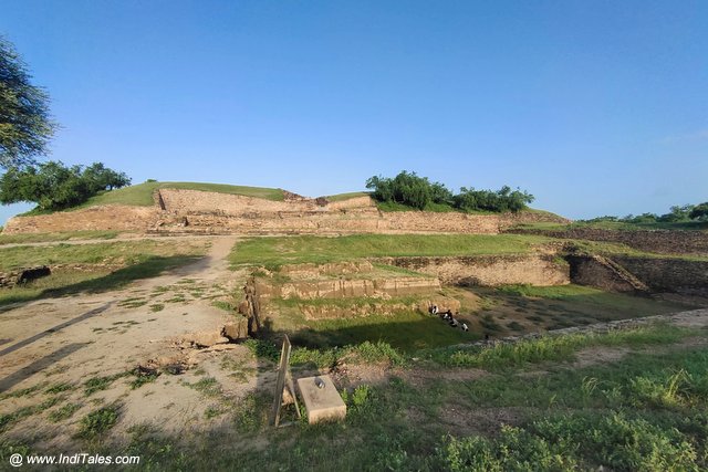
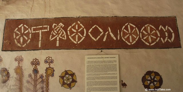
To a visitor, the first striking feature is the imposing citadel rising above ground level. Standing before the east entrance at sunrise, it reminded me of the Borobudur Temple in Indonesia, a site I had also visited early in the morning. The citadel has major four gates aligned with the cardinal directions. The northern gate once featured a massive wooden door and a large signboard with ten letters—possibly the oldest known signboard in the world. Although the script remains undeciphered, some scholars believe interpretations are possible.
We entered through this north gate; the signboard is now preserved in a museum. The gate passageway is flanked by chambers likely occupied by guards. A staircase, presently a temporary wooden structure for visitors’ safety, leads to the top where the full site is visible against the sky.
At first, the stone formations seem random, but the southeastern section, the highest mound, was the castle. However, over time, the distinction between this and other areas has blurred.
Continuity of Civilization
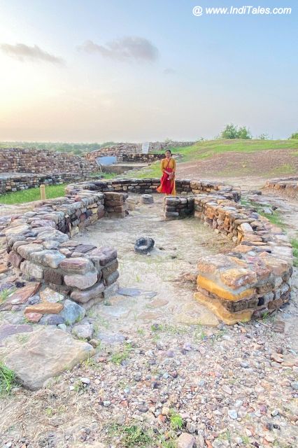
What fascinated me most were the circular foundations bearing a striking resemblance to the traditional Bhoonga huts of Kutch. This earthquake-resistant design may reveal a link between the ancient Indus inhabitants and current locals. Some foundations include a small central pole-like stone, suggesting they were used for oil extraction with animals like bulls—a Kolhu in Hindi.
The east gate likely led directly to the castle, with limestone pillars quarried 2-3 km away still visible. Throughout Indus sites, rooms tend to be notably small, leading me to wonder whether they served as dwellings or storage spaces for trading goods. Adjacent to the west gate lies a bead factory, which may have functioned as an administrative or commercial office. The western castle area, called Bailey or Upa-Prasad in Hindi, was probably home to the non-royal elite. Nearby stand four square granaries.
Water Management at Dholavira
Dholavira’s most impressive feature is its advanced hydraulic engineering. Positioned between the seasonal Mansar and Manhar rivers, archaeologists uncovered several check dams used to channel water to large reservoirs via stone-carved waterways. Such dams are unique to Dholavira among Indus Valley sites.
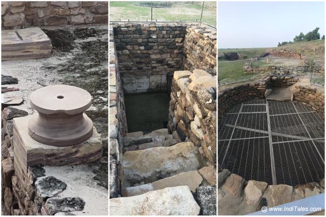
As you enter, a massive water reservoir with staircases descending 30 steps at three corners stands out. The reservoir contains rock-cut wells and stone steps, possibly the earliest prototypes of stepwells like Rani Ki Vav. Nearby, a unicorn figurine suggests the reservoir’s ceremonial importance to the people.
Atop the site are two large stepwells and a round well, the latter measuring four meters in diameter—possibly the largest well found in Indus Valley sites. Rope marks on a stone slab indicate use of a pulley system to draw water.
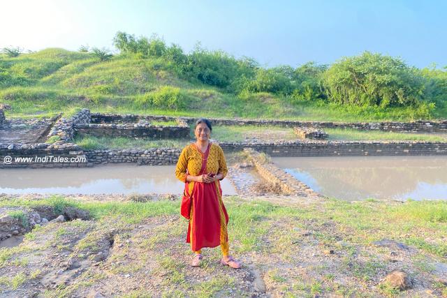
Most fascinating are the southern water management tanks—a sequence of five interconnected reservoirs for storing and filtering water. The first two tanks manage desilting, the central third reservoir is three times larger than the Great Bath at Mohenjo-daro, and the fourth tank features a ramp for wheeled carriage access reminiscent of Surajkund. The fifth tank channels water to western tanks.
These reservoirs are excavated on rocky plateau beds and topped with brick and masonry embankments.
Imagine a city surrounded by water, expertly capturing river flows and rain to maintain ample supply year-round. Archaeologists discivered at least 16 water reservoirs, underscoring the ancient proverb, “Jal hi Jeevan hai” — water is life.
Excavations and Artifacts
Excavations at Dholavira uncovered ceramics, beads, pillar fragments, shell objects, semi-precious stones, copper items, seals, terracotta unicorn figurines, stone bangles, gold, fishhooks, copper ingots, jars, and pottery. Many items point to strong trade links with West Asia.
Visiting Dholavira is like stepping into a vibrant chapter of history that continues to teach us valuable lessons.
Travel Tips for Dholavira
- Allocate about two hours to explore the site thoroughly.
- Entry is free, and the site opens from sunrise to sunset. Early morning visits offer the best lighting and a comfortable climate for photography.
- Guides are available but not in early morning hours.
- The museum is closed on Fridays, so plan accordingly.
- Several resorts surround Dholavira, offering attractive rates during lean seasons but higher prices during the Kutch festival.


I Have Read This Post. Great Article!!!!……..Thanks For Sharing
good Article!!!!……..Thanks For this…
Visit another one
Vey informative blog. Nice I am loving it.